
Terra Nova Bay or Bust
 9 comments
 MCMURDO STATION, ANTARCTICA– It has been a slow, and sometimes frustrating, effort to get our first successful science flight of the project, but we did succeed last night. Before discussing that flight I’d like to write about some of the hurdles we have had to overcome to get to this point.
The first obstacle, and the one least in our control, was the weather. The Aerosonde unmanned aerial vehicles (UAVs) have been flown in temperatures as cold as -30 degrees C (-22 deg F), and this was the intended minimum operating temperature for this project. Prior to coming to Antarctica one of the members of my research group, Shelley Knuth, analyzed 14 years of automatic weather station data from a weather station located at the Pegasus runway that we are using for our UAV flights. Based on her analysis the temperature at Pegasus is above -30 degrees C for approximately 50% of the time in September, and is below -40 degrees C (which is also -40 degrees F) only 9% of the time in September on average. Of course the weather for any given month rarely follows the average, and this September has been a colder than average September, with most days up until the past few days having temperatures below -30 degrees C at Pegasus, and many days having temperatures below -40 degrees C. This made our attempts to fly the Aerosondes very difficult.
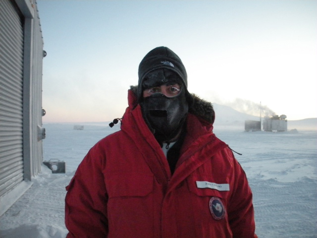
Me at Pegasus runway when the temperature was -54 deg F. It was much too cold on this day to attempt an Aerosonde flight.
The two problems we have when trying to fly the Aerosondes at cold temperatures are keeping the engine warm in the time between taking it out of the hangar and getting it loaded into its launch cradle and having various parts of the plane break due to the extreme cold.
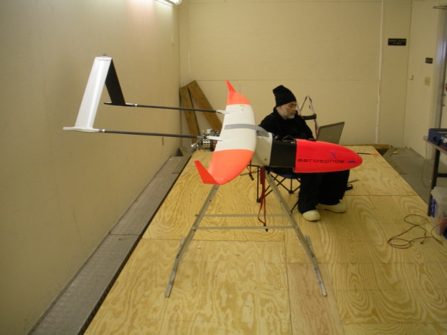
Peter prepping an Aerosonde in the hangar.
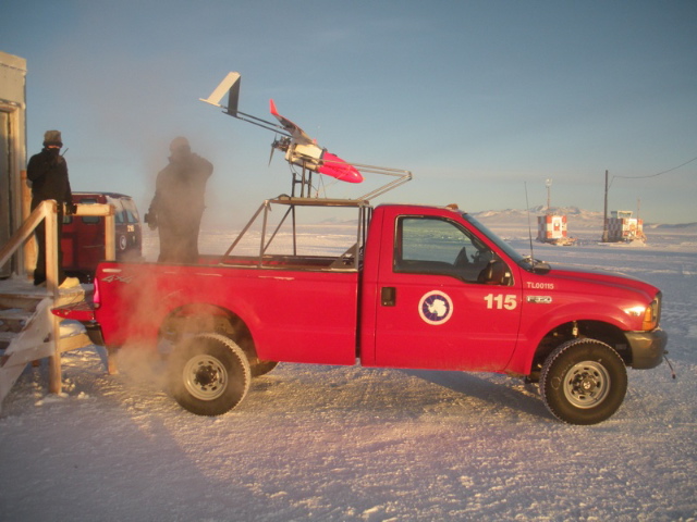
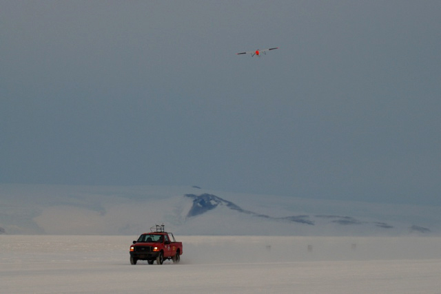
Aerosonde loaded into launch cradle on pickup truck.
Our most difficult cold weather flight of the trip took place on September 10th. This was supposed to be our first “science” flight to Terra Nova Bay, the location of the polynya (area of open water surrounded by sea ice) that is the focus of the project. The temperature at the time of this flight was near -40 degrees F. It took us three attempts to get the Aerosonde loaded into the launch cradle and get the engine started. Between each attempt we needed to bring the Aerosonde back into the hangar and warm the engine by wrapping it in two electric car battery warmers. We eventually had the plane ready to fly, although we were now quickly approaching the end of daylight, as the sun had already set. Despite the difficult conditions we had a successful launch. Just 15 minutes into the flight we received a warning from the flight control computer that the generator had stopped charging the battery on the plane. This is a serious problem, as the battery holds very little charge in the cold conditions, and without the battery the avionics, that control the aircraft, will shutdown causing the plane to crash. The Aerosonde crew quickly turned the plane around and had it fly back to Pegasus as fast as possible. Luckily the battery held out until the plane landed, although the landing was quite difficult given the quickly fading light.
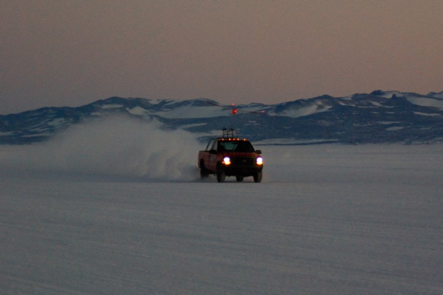
Aerosonde launch after sunset on 10 September, when the temperature was near -40 degrees F.
The second major obstacle we have faced has been aircraft failures. The Aerosondes are designed as semi-disposable aircraft, so it is expected that during a project like ours, we will lose some aircraft to mechanical problems. On our first flight to Terra Nova Bay, on 9 September 2009, the Aerosonde crashed roughly 6.5 hours into the flight, as it was returning from Terra Nova Bay. The apparent cause of the crash was a fuel pump failure, which caused the engine to shutdown. It was very depressing to watch the display on the ground control computer as the plane slowly lost altitude and finally crash landed on the sea ice north of Ross Island.
On our third attempted flight to Terra Nova Bay, on 12 September we had much nicer weather. The temperature at the time of the launch was -26 degrees C (-15 degrees F). The plane took off from Pegasus shortly after 4PM.
Aerosonde launch on 12 September.
About 3 hours into the flight we lost communications with the aircraft. The communications with the plane are done via VHF radio for line of sight flights and by Iridium satellite phone for over the horizon flights, like our Terra Nova Bay flights. The flight path uploaded to the plane is such that if communications are lost for more than a specified amount of time (30 minutes in our case) the plane returns to a designated waypoint. For this mission that waypoint was over the Pegasus runway. 30 minutes after we lost communication with the plane it turned from its original flight path, which would have taken it to Terra Nova Bay, and began the flight back to Pegasus. We were hoping that the communications failure was just an Iridium phone failure and that we’d regain contact with the plane when it returned to radio range. Nick and Paul estimated that the plane would return to radio range between 8:30 and 9PM. These times came and went and we still didn’t have contact with the plane. By 10PM we’d given up hope that the plane was still in the air, and began to wonder if another problem had occurred causing the plane to crash. At 10:30PM we were relieved when we regained radio contact with the plane. The large delay between the expected return of communications and actually regaining communications was likely due to stronger headwinds than anticipated on the return flight and not getting radio contact as far out as we had expected. We were very relieved, to say the least, that the plane was still in the air and under our control again.
At this point we decided to bring the plane back to Pegasus and have it circle the runway until first light the next morning when we could land it safely. The total length of this flight was 17 hours, which to our knowledge is by far the longest UAV flight ever made in Antarctica (the previous longest UAV flights, done by the British Antarctic Survey were only a couple of hours in length).

Aerial photo of the north end of the Pegasus runway taken by the Aerosonde during final approach for landing. The runway angles towards the bottom left edge of the photo. You can see three vehicles that are waiting to recover the Aerosonde after it lands parked on the side of the runway.
Our fourth attempt to fly to Terra Nova Bay was a success. We launched the plane last night (Monday night) at 4:30PM. The temperature at the time of the launch was -31 degrees C (-24 degrees F).
Here’s a video of the Aerosonde launch on Monday 14 September.
Get the Flash Player to see this player.
We spent all night monitoring this flight. We chose to do an overnight flight because we had planned a flight time of 15 hours, which would allow us 5 or 6 hours over Terra Nova Bay, plus the 9+ hours of transit time to get to and then return from Terra Nova Bay. Since we have a bit less than 12 hours of daylight here right now the only way to do a 15 hour flight, where we take-off and land in daylight, is to take-off in the late afternoon and land early the next morning.
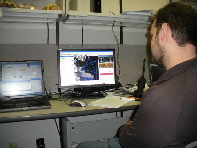
Paul monitoring our Terra Nova Bay Aerosonde flight on the ground control computer in the Crary lab in McMurdo.
Our science objective for this flight was to measure the horizontal and vertical extent of the katabatic winds that blow over Terra Nova Bay, and push sea ice away from the coast creating the polynya. Katabatic winds are cold winds that drain from the interior of the Antarctic ice sheet to the coast. There are several locations around the coast of Antarctica where these katabatic winds are particularly strong, and Terra Nova Bay is one of those locations.
During the 2 days prior to this Aerosonde flight an automatic weather station on the coast of Terra Nova Bay was reporting wind speeds in excess of 70 mph, with gusts well above 110 mph. By the time our Aerosonde arrived at Terra Nova Bay the winds had subsided a little bit, but we still flew through winds up to 65 mph.
The onset of the katabatic winds during our flight was very abrupt, with our plane flying from winds of roughly 10 mph to winds in excess of 45 mph in just over 5 miles of distance. The observations of the katabatic winds that we made last night are the first three dimensional observations of these winds in the winter, when they are most intense. The only other direct observations we have of these winds during the winter are from automatic weather stations, which provide information just a few feet above the ground. The data we collected last night allowed us to accurately map the horizontal and vertical extent of the katabatic winds with a level of detail never achieved previously. We will use the data we collected to verify our theories and computer model predictions of these intense katabatic winds and to study the relationship between the strong katabatic winds and the Terra Nova Bay polynya.
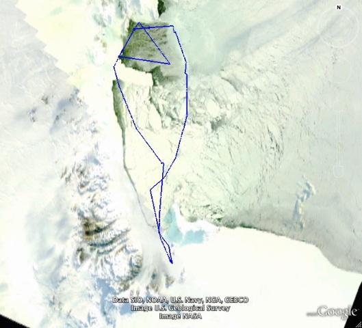
Map of our first successful Terra Nova Bay science flight with the Aerosonde. The background image is a satellite image showing the sea ice extent several hours prior to our flight. The darker area near the top of the map (where the triangular flight path is located) is the Terra Nova Bay polynya.


Congratulations on the successful flight! Great write-up as well, thanks. Any chance of recovering the downed Aerosonde, or are they unrecoverable once they go down?
Hi All,
Thanks for all of the comments on the posts.
Darin – Terry is down here right now and we’ve chatted lots about the beautiful polar stratospheric clouds we’ve been seeing here for the last week or so.
Brett- Sorry. I’ve got a pretty long waiting list of people that want to come down for our next trip.
Bobby, Harry – thanks for the comments about the early days of the US operations in Antarctica. I’m sure it was a different world down here then and much more of an adventure then it is today.
Matt – the downed Aerosonde is on loose sea ice (as opposed to fast ice that is attached to the land) so any attempt to retrieve it would be pretty risky. I’m not expecting that we’ll see it again.
Cheers,
John
Nice work guys. Interesting flight path.
Well done.
What an adventure.
Bloody amazing.
great blog…here’s to successful missions ahead!(should rename the place “Aero-Sound”…)
John – Great pics of the Aerosonde! Those first few launches must have been so tough. How great to have a successful flight under your belt…and a record-setting one at that! Very excited to hear about the mapping of the Katabatic winds. It will be terrific to see those results, once you’ve done the analysis.
Stay warm!
Adriana
Well done! I got a kick out of that launch from a pickup truck; it broke me up. Worked like a charm -:). How did you manage to stay up for 15 hours? Long-range tanks?
–Roger Williams, NOAA/GMCC (GMD) veteran, BRW-MLO (TDY)-SMO (but not SPO).
Teammates–
There needs to be much better data collection, mapping and predicting of the ice layers, holes and movement in Antartica and Greenland over the next 10 years. We need to better understand the overall air/land/temperature effects going on around these two critical land mass areas. If there is a “tipping point” in the overall movement of the ice shelfs, it is better to know about it as soon as possible.
Richard Wagaman
NASA ERAST Board, Industry Representative
Wow, it’s quite amazing that this can be done at all, and to trouble shhot in such harsh conditions must be frustrating but rewarding at the same time.
Keep up the great work!
Jody