To Capture a Polar Bear
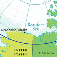
DEADHORSE, ALASKA– Currently, the best scientific estimate of the worldwide population of polar bears is about 20,000 to 25,000 animals. This population – which is “circumpolar” and stretches all the way around the Arctic – is geographically divided into 20 subunits. Bears move between these subunits, but radio-collar tracking indicates that most bears remain within their subunit (some genetic evidence supports the existence of the subunits as well).
Nineteen of these subunits are populations of several hundred to several thousand bears; the 20th subunit is the Arctic basin, the area surrounding the geographic North Pole. Bears have been observed almost all the way north to the pole, but it is unknown if any bears are actually residents there. You can see a map of the subunits at this website: http://pbsg.npolar.no/en/status/population-map.html.
Some of the most well-studied polar bears are in western Hudson Bay, where bears come ashore near Churchill, Canada, during the fall months. Bears in the southern Beaufort Sea are also well-studied – this is the subunit of bears on which we are focusing. It is difficult to study what may be the most mobile mammal on earth; in some areas polar bears have home ranges over 500,000 sq km. Because bears move over such a large area and because they travel on variable sea ice, they are difficult to trap. Instead, finding and darting bears from a low-flying helicopter is the most common capture method.
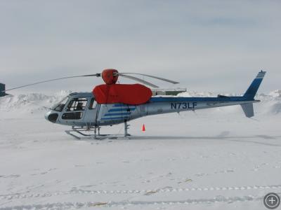
We are using this helicopter this spring as a platform from which to dart bears. The pilot maneuvers the helicopter low and close to the bear, then a gunner leans out the window on the far side and uses a specialized firearm to shoot a dart into the bear. The dart contains a drug that immobilizes the animal and puts them under anesthesia. Here, the helicopter is parked in front of the lab with covers over the engine and the base of the rotors; space heaters beneath the covers keep critical components warm enough to start in the morning.
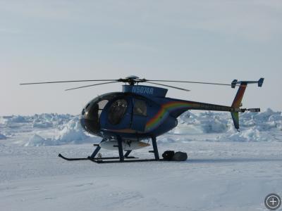
We are using this helicopter to aid in spotting bears, and to carry personnel and gear. It is smaller than the darting helicopter. The white tank attached to the belly is an extra fuel tank, giving us an additional 30 minutes or so of flight time.
The sea ice at this time of year is very interesting. Almost the entire Arctic Ocean is frozen over, creating vast ice sheets. Ocean currents and wind push these sheets against each other and they break and crumple into jumbled ridges where they meet. This leaves a totally flat landscape punctuated by randomly-strewn ice chunks, some bigger than houses. It is an otherworldly place to fly over, and to walk through.
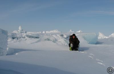
This is me crouched in front of some ice blocks near our last capture site, on the sea ice about 30 miles north of the coast of Alaska.
We have been down for weather for several days. After working in Kaktovik last weekend, we used a charter plane to haul all of the USGS gear to Deadhorse. We set up all of their base equipment and got out for a capture on Monday afternoon. It was about 0 degrees (Fahrenheit) and mostly sunny. The weather began to turn that night, steadily becoming warmer, windier, and cloudier. Several inches of snow fell yesterday afternoon as well. All of these factors have reduced visibility to the point where we cannot fly. However, the skies are clearing this afternoon, so we hope to get back out today.





The sea ice looks beautiful – but also ever-changing. How do the pilots know when its safe for them to put the helicopter on the ice?
Hi,
The sea ice sure is beautiful. I have really enjoyed being up here in the summer and fall, but being out on multi-year ice (ice that formed over a year ago and survived a melt season) that is all jumbled has been a completely different experience. It is a stunning place, all blue and white with sharp plates of ice everywhere.
You have a good sense of how thick and old ice is just by looking down at it – for example, thick multi-year ice often has jumbled plates piled on it and large flat areas with no cracks. Thinner ice is a darker color as well. When there is any doubt, the pilot lightly lands the helicopter and lightly bounces several times to see if the ice or snow beneath shifts.
bouncing on the ice to see if its safe – good lord. Well, to each his own!
Wow! I hope to fly the arctic sometime. I’m a helicopter pilot now, but still have low time so it’ll be a few years before I can start looking for these types of jobs. I can’t wait though!
What a unique place to conduct your research – truly spectacular. I share a common dream with israel donaldson in that I too wish to become a helicopter pilot and fly the arctic.
Thanks for sharing your experiences.
Regards, James Kelling.
James_<JK@hotmail.com