
The Melting Arctic Ice
 2 comments
 LARAMIE, WYOMING– While I am spending the summer back at the University of Wyoming, the Arctic summer is in full swing. In Deadhorse, northern Alaska, the sun now hangs in the sky for 24 hours a day. By early June temperatures had risen above freezing, and they have been hovering in the 30s (Fahrenheit) for most of the month. Sea ice breakup has accelerated, and Arctic ice extent declined rapidly throughout June.
During June, the Arctic lost an average of 26,400 square miles of ice per day. It is normal for Arctic ice to melt throughout the summer and refreeze throughout the winter. However, the pace and extent of ice melt in the summer has increased dramatically in recent years. Precise satellite measurements of ice began in 1979. To investigate ongoing changes in ice cover, many scientists compare measurements to averages from the period of 1979-2000. For example, Arctic ice covered an area of 4.43 million square miles during June, an area that was 270,000 square miles less than the 1979-2000 average for June. In other words, there was less ice in June than in a typical year. This is representative of a long-term trend of less ice every year; since 1979, Arctic ice cover in June has declined by about 3% per decade.
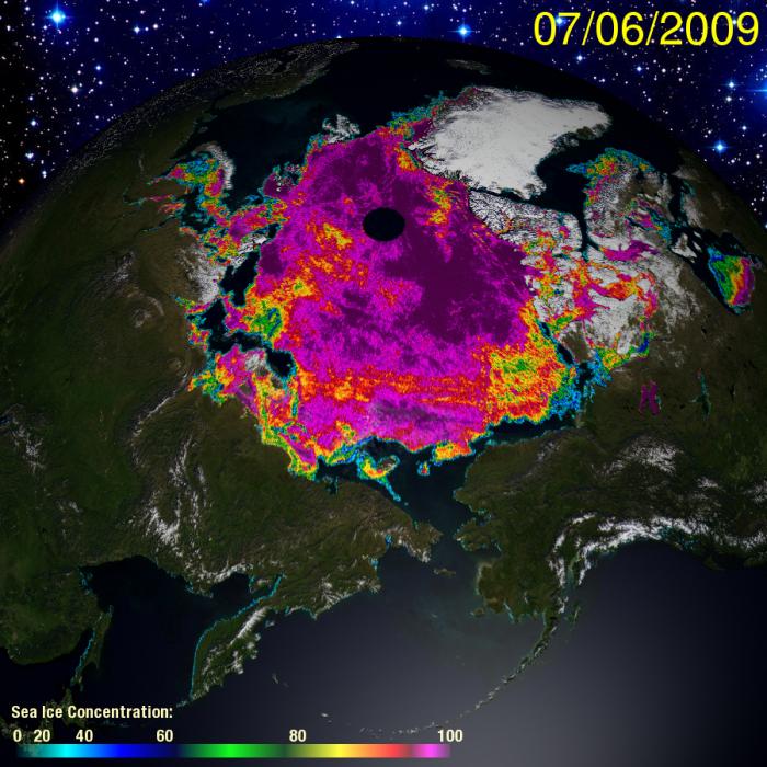
This satellite image shows Alaska in the lower right and Russia in the lower left. The black dot in the center is near the geographic north pole and shows an area that has no ice data. The sea ice is falsely colored and coded by concentration. Areas with low concentration are mostly open water with little ice; areas with high concentration are mostly ice, with little open water. This image has been reproduced from The Cryosphere Today, a website of the University of Illinois. Snow and ice data provided by the National Center for Environmental Prediction/NOAA.
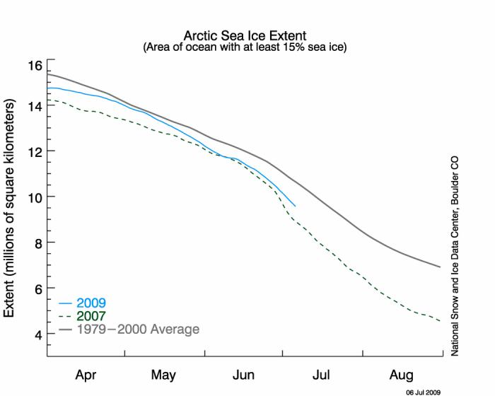
The gray line depicts the average extent of ice in the Arctic over the years 1979-2000. The green dashed line depicts the extent during the record year of 2007, when ice extent was the lowest on record. The blue line depicts 2009. Ice extent has been low this year, but thus far, not record-breaking low. This chart has been reproduced from the website for the National Snow and Ice Data Center (http://nsidc.org/arcticseaicenews/).
There are several online resources to track changes in Arctic ice extent. The National Snow and Ice Data Center tracks daily ice extent and provides historical comparisons and analyses. The website is http://nsidc.org/arcticseaicenews/. The Cryosphere Today is a website of the University of Illinois at Urbana-Champaign, Department of Atmospheric Sciences. This website also provides ice extent data, as well as detailed satellite images that clearly show the current ice extent.
Although satellite measurements of ice extent are only available beginning in 1979, some scientists have used other resources – such as ice charts created for shipping traffic – to piece together a longer history of Arctic ice extent. One group of scientists examined data from 1953 to 2005 and found that the Arctic ice extent in September declined by about 8% per decade (Meier et al. 2007; see citation below). In other words, on average, every year there is 8% less ice in September than the previous September. This raises the possibility that in the near future, there will be no ice in September of each year; that is, Arctic ice could completely melt every summer. That scenario would be a dramatic departure from the Arctic that we know today.
I have spent my summer mostly working on logistics and equipment for future capture work. I will return to Deadhorse on July 29th to set up our lab and prepare for August work. We will capture bears on shore and perform sampling during the first half of August. Afterwards, I will return to the University of Wyoming for several weeks. In late September our research team will travel to Barrow, which is a town west of Deadhorse on the Alaskan coast. From Barrow, we will use helicopters to board a US Coast Guard ship – the icebreaker POLAR SEA – to travel north to the edge of the retreating Arctic ice. During the month of October, we will remain at sea, launching in helicopters to recapture collared polar bears that have followed the sea ice north for the summer.
Each capture operation requires several hundred pounds of gear that needs to be sorted, packed, and shipped. Unfortunately, half of the gear that I shipped back to the University at the end of May was lost in transit. I spent a frantic three weeks on the phone, calling every shipping dock where the equipment may have gone. Finally, on the day I began purchasing replacement gear, I received a call that the equipment had shown up in Salt Lake City, Utah, and could be sent to me immediately. That was quite a relief. Now, I am back to sorting and packing in anticipation of August.
Citation
Meier, Stroeve, Fetterer. 2007. Whither Arctic sea ice? A clear signal of decline regionally, seasonally and extending beyond the satellite record. Annals of Glaciology 46:428-434.


Error bars…please.
Otherwise…you ain’t got jack.
Hi Sirius,
Thanks for reading the dispatch. Understanding the variability in a data set is indeed critical when describing trends. Throughout most of June 2009, ice extent fell about 2 standard deviations below the 1979-2000 mean. The chart that is presented above, but with standard deviations indicated by gray shading, can be found at http://nsidc.org/images/arcticseaicenews/20090706_Figure2.png. During April and May, the ice extent was below the 1979-2000 mean, but usually within 2 standard deviations of the mean.
Even better than visualizing the variability is examining the full data set. The website The Cryosphere Today provides a graph of ice extent anomaly from the 1979-2000 average, for the entire data set from 1979 to today. Following the graph from left to right, the downward trend is apparent. The graph is available from their main website http://arctic.atmos.uiuc.edu/cryosphere/ where it is titled “Tale of the Tape”, or here at http://arctic.atmos.uiuc.edu/cryosphere/IMAGES/sea.ice.anomaly.timeseries.jpg.
Variability in the data can also be described by testing for significance of trends. Meier et al. (2007) (see the citation above) tested for significant trends in the 1979-2006 satellite data of ice extent. They found that ice extent exhibited a significant decline in every month of the year, with the most dramatic declines occurring in summer months. The significance testing used an F test with a 99% confidence level and a null hypothesis of a zero trend. It is worth noting that the decline in ice is significant across the Arctic, but it is heterogeneous in space and time. Some regions of the Arctic are experiencing dramatic loss while other areas are experiencing little or no loss. I encourage you to read their paper for a detailed description.