How Do We Map the Ocean Floor?
 No comments
 ABOARD THE JOIDES RESOLUTION, ON THE BERING SEA– So here’s something I never had questioned before: How do we know what the ocean floor looks like? I found out a bit of the history of how we know what we know.
After I toured the Underway Lab on the aft end of the JR yesterday, I was formally introduced to the Precision Depth Recorder. A nice sonar array lies on the bow end of the ship below and behind the forward underway thruster. As we travel the sonar emits a chirp of sound from 12 different sources towards the ocean floor. The receiver picks up the echo (and also secondary echoes as the sound bounces back up, down and back again) and plots it for us. Through this we can visualize signal strength and since we know the speed of sound we can measure distance. This helps us to determine the depth of the ocean at our given location. Sonar stands for “sound navigation and ranging”.
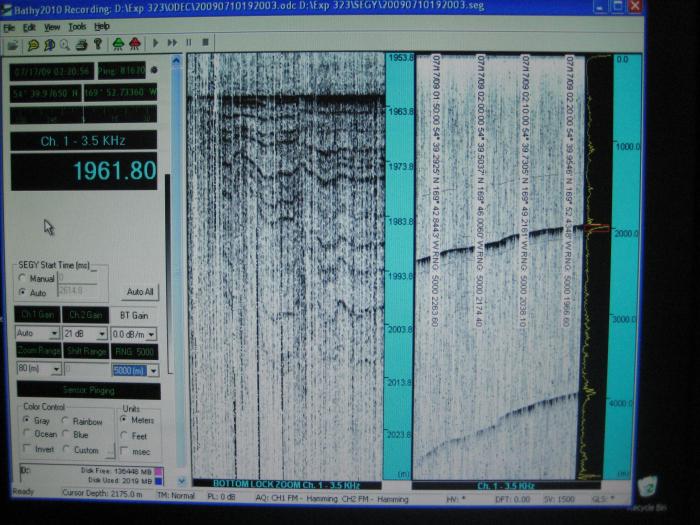
The Precision Depth Recorder uses sonar to image the ocean floor.
And now we get to the cool part. At some point the military began collecting all of this data for any ships it could get its hands on. Obviously their intent was not scientific, but they took enough lines of travel across the ocean and combined them to create a workable map of the ocean floor. Imagine doing a tombstone rubbing with a crayon, but instead of broad strokes covering the entire surface, you can only make single line marks. And those lines may not cover all of the information. Now you have to read what was on the tombstone. Sure, it isn’t a perfect method, but it got us started, and I think it is pretty cool.
*****
We retrieved four sections of core from hole U1339A today. After a problem with drilling equipment they decided it was best to pull out of the A hole and move on to a new one, the B hole. In a way this is good. It gives the scientists a relatively small amount of core to work with now, and get the sampling methods firmed up before the near constant flood of core starts arriving. But a delay is a delay, and no one wants to sacrifice a later part of our expedition for lost time now. Hopefully we’ll make up some of the time later if the weather is good for our next transit.

Using rhizons (a soil water extracting device), we drilled holes into the core casing and pulled pore water out with suction from syringes.
One of the sampling techniques that we used today was the removal of pore water from the cores. Using rhizons (a soil water extracting device), we drilled holes into the core casing and pulled water out with suction from syringes. Pretty cool, right? This is water that was trapped in the mud on the bottom of the ocean, for a long time, maybe millions of years (to be fair, the mud we are currently exploring is not that old… forgive the embellishment – maybe thousands?). What will we find? Hard to say right now, as much of the testing will be done later. But it all starts here.